APPENDIX A
FIELD SKETCHING
A sketch is a free-hand drawing of a map or picture of an area or route of travel. It shows enough detail and has enough accuracy to satisfy special tactical or administrative requirements.
A-1. PURPOSE
Sketches are useful when maps are not available or the existing maps are not adequate, or to illustrate a reconnaissance or patrol report. Sketches may vary from hasty to complete and detailed, depending upon their purpose and the degree of accuracy required. For example, a sketch of a large minefield will require more accuracy than a hasty sketch of a small unit’s defensive position.
A-2. MILITARY SKETCHES
The scale of a sketch is determined by the object in view and the amount of detail required to be shown. The sketch of a defensive position for a platoon or company normally calls for a sketch of larger scale than a sketch for the same purpose for a division. Military sketches also include road and area sketches.
a. Field Sketches. A field sketch (Figure A-1) must show the north arrow, scale, legend, and the following features:
-
Power lines.
-
Rivers.
-
Main roads.
-
Towns and villages.
-
Forests.
-
Rail lines.
-
Major terrain features.
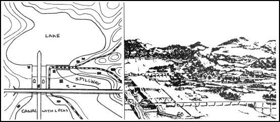
Figure A-1. Sketch map.
b. Road Sketches. These sketches show the natural and military features on and in the immediate vicinity of the road. In general, the width of terrain sketches will not exceed 365 meters on each side of the road. Road sketches may be used to illustrate a road when the existing map does not show sufficient detail.
c. Area Sketches. These sketches include those of positions, OPs, or particular places.
(1) Position Sketch. A position sketch is one of a military position, campsite, or other area of ground. To effectively complete a position sketch, the sketcher must have access to all parts of the area being sketched.
(2) Observation Post Sketch. An OP sketch shows the military features of ground along a friendly OP line as far toward the enemy position as possible.
(3) Place Sketch. A place sketch is one of an area made by a sketcher from a single point of observation. Such a sketch may cover ground in front of an OP line, or it may serve to extend a position or road sketch toward the enemy.
Land Navigation Training Software
- Chapter 1: TRAINING STRATEGY
- Chapter 2: MAPS
- Chapter 3: MARGINAL INFORMATION AND SYMBOLS
- Chapter 4: GRIDS
- Chapter 5: SCALE AND DISTANCE
- Chapter 6: DIRECTION
- Chapter 7: OVERLAYS
- Chapter 8: AERIAL PHOTOGRAPHS
- Chapter 9: NAVIGATION EQUIPMENT AND METHODS
- Chapter 10: ELEVATION AND RELIEF
- Chapter 11: TERRAIN ASSOCIATION
- Chapter 12: MOUNTED LAND NAVIGATION
- Chapter 13: NAVIGATION IN DIFFERENT TYPES OF TERRAIN
- Chapter 14: UNIT SUSTAINMENT
- Appendix A: FIELD SKETCHING
- Appendix B: MAP FOLDING TECHNIQUES
- Appendix C: UNITS OF MEASURE AND CONVERSION FACTORS
- Appendix D: JOINT OPERATIONS GRAPHICS
- Appendix E: EXPORTABLE TRAINING MATERIAL
- Appendix F: ORIENTEERING
- Appendix G: M2 COMPASS
- Appendix H: ADDITIONAL AIDS
- Appendix I: FOREIGN MAPS
- Appendix J: GLOBAL POSITIONING SYSTEM
- Appendix K: PRECISION LIGHTWEIGHT GLOBAL POSITIONING SYSTEM RECEIVER
- Map Reading and Land Navigation GLOSSARY
- Map Reading and Land Navigation REFERENCES