Chapter 3
MARGINAL INFORMATION AND SYMBOLS
A map could be compared to any piece of equipment, in that before it is placed into operation the user must read the instructions. It is important that you, as a soldier, know how to read these instructions. The most logical place to begin is the marginal information and symbols, where useful information telling about the map is located and explained. All maps are not the same, so it becomes necessary every time a different map is used to examine the marginal information carefully.
3-1. MARGINAL INFORMATION ON A MILITARY MAP
Figure 3-1 shows a reduced version of a large-scale topographic map. The circled numbers indicate the items of marginal information that the map user needs to know. These circled numbers correspond to the following listed items.
a. Sheet Name (1). The sheet name is found in bold print at the center of the top and in the lower left area of the map margin. A map is generally named for the settlement contained within the area covered by the sheet, or for the largest natural feature located within the area at the time the map was drawn.
b. Sheet Number (2). The sheet number is found in bold print in both the upper right and lower left areas of the margin, and in the center box of the adjoining sheets diagram, which is found in the lower right margin. It is used as a reference number to link specific maps to overlays, operations orders, and plans. For maps at 1:100,000 scale and larger, sheet numbers are based on an arbitrary system that makes possible the ready orientation of maps at scales of 1:100,000, 1:50,000, and 1:25,000.
c. Series Name (3). The map series name is found in the same bold print as the sheet number in the upper left corner of the margin. The name given to the series is generally that of a major political subdivision, such as a state within the United States or a European nation. A map series usually includes a group of similar maps at the same scale and on the same sheet lines or format designed to cover a particular geographic area. It may also be a group of maps that serve a common purpose, such as the military city maps.
d. Scale (4). The scale is found both in the upper left margin after the series name, and in the center of the lower margin. The scale note is a representative fraction that gives the ratio of a map distance to the corresponding distance on the earth’s surface. For example, the scale note 1:50,000 indicates that one unit of measure on the map equals 50,000 units of the same measure on the ground.
e. Series Number (5). The series number is found in both the upper right margin and the lower left margin. It is a sequence reference expressed either as a four-digit numeral (1125) or as a letter, followed by a three- or four-digit numeral (M661; T7110).
f. Edition Number (6). The edition number is found in bold print in the upper right area of the top margin and the lower left area of the bottom margin. Editions are numbered consecutively; therefore, if you have more than one edition, the highest numbered sheet is the most recent. Most military maps are now published by the DMA, but older editions of maps may have been produced by the US Army Map Service. Still others may have been drawn, at least in part, by the US Army Corps of Engineers, the US Geological Survey, or other agencies affiliated or not with the United States or allied governments. The credit line, telling who produced the map, is just above the legend. The map information date is found immediately below the word “LEGEND” in the lower left margin of the map. This date is important when determining how accurately the map data might be expected to match what you will encounter on the ground.
g. Index to Boundaries (7). The index to boundaries diagram appears in the lower or right margin of all sheets. This diagram, which is a miniature of the map, shows the boundaries that occur within the map area, such as county lines and state boundaries.
h. Adjoining Sheets Diagram (8). Maps at all standard scales contain a diagram that illustrates the adjoining sheets. On maps at 1:100,000 and larger scales and at 1:1,000,000 scale, the diagram is called the index to adjoining sheets. It consists of as many rectangles representing adjoining sheets as are necessary to surround the rectangle that represents the sheet under consideration. The diagram usually contains nine rectangles, but the number may vary depending on the locations of the adjoining sheets. All represented sheets are identified by their sheet numbers. Sheets of an adjoining series, whether published or planned, that are at the same scale are represented by dashed lines. The series number of the adjoining series is indicated along the appropriate side of the division line between the series.
i. Elevation Guide (9). This is normally found in the lower right margin. It is a miniature characterization of the terrain shown. The terrain is represented by bands of elevation, spot elevations, and major drainage features. The elevation guide provides the map reader with a means of rapid recognition of major landforms.
j. Declination Diagram (10). This is located in the lower margin of large-scale maps and indicates the angular relationships of true north, grid north, and magnetic north. On maps at 1:250,000 scale, this information is expressed as a note in the lower margin. In recent edition maps, there is a note indicating the conversion of azimuths from grid to magnetic and from magnetic to grid next to the declination diagram.
k. Bar Scales (11). These are located in the center of the lower margin. They are rulers used to convert map distance to ground distance. Maps have three or more bar scales, each in a different unit of measure. Care should be exercised when using the scales, especially in the selection of the unit of measure that is needed.
l. Contour Interval Note (12). This note is found in the center of the lower margin normally below the bar scales. It states the vertical distance between adjacent contour lines of the map. When supplementary contours are used, the interval is indicated. In recent edition maps, the contour interval is given in meters instead of feet.
m. Spheroid Note (13). This note is located in the center of the lower margin. Spheriods (ellipsoids) have specific parameters that define the X Y Z axis of the earth. The spheriod is an integral part of the datum.
n. Grid Note (14). This note is located in the center of the lower margin. It gives information pertaining to the grid system used and the interval between grid lines, and it identifies the UTM grid zone number.
o. Projection Note (15). The projection system is the framework of the map. For military maps, this framework is of the conformal type; that is, small areas of the surface of the earth retain their true shapes on the projection; measured angles closely approximate true values; and the scale factor is the same in all directions from a point. The projection note is located in the center of the lower margin. Refer to DMA for the development characteristics of the conformal-type projection systems.
(1) Between 80° south and 84° north, maps at scales larger than 1:500,000 are based on the transverse Mercator projection. The note reads TRANSVERSE MERCATOR PROJECTION.
(2) Between 80° south and 84° north, maps at 1:1,000,000 scale and smaller are based on standard parallels of the lambert conformal conic projection. The note reads, for example, LAMBERT CONFORMAL CONIC PROJECTIONS 36° 40’ N AND 39° 20’ N.
(3) Maps of the polar regions (south of 80° south and north of 84° north) at 1:1,000,000 and larger scales are based on the polar stereographic projection. The note reads POLAR STEREOGRAPHIC PROJECTION.
p. Vertical Datum Note (16). This note is located in the center of the lower margin. The vertical datum or vertical-control datum is defined as any level surface (for example, mean sea level) taken as a surface of reference from which to determine elevations. In the United States, Canada, and Europe, the vertical datum refers to the mean sea level surface. However, in parts of Asia and Africa, the vertical-control datum may vary locally and is based on an assumed elevation that has no connection to any sea level surface. Map readers should habitually check the vertical datum note on maps, particularly if the map is used for low-level aircraft navigation, naval gunfire support, or missile target acquisition.
q. Horizontal Datum Note (17). This note is located in the center of the lower margin. The horizontal datum or horizontal-control datum is defined as a geodetic reference point (of which five quantities are known: latitude, longitude, azimuth of a line from this point, and two constants, which are the parameters of reference ellipsoid). These are the basis for horizontal-control surveys. The horizontal-control datum may extend over a continent or be limited to a small local area. Maps and charts produced by DMA are produced on 32 different horizontal-control data. Map readers should habitually check the horizontal datum note on every map or chart, especially adjacent map sheets. This is to ensure the products are based on the same horizontal datum. If products are based on different horizontal-control data, coordinate transformations to a common datum must be performed. UTM coordinates from the same point computed on different data may differ as much as 900 meters.
r. Control Note (18). This note is located in the center of the lower margin. It indicates the special agencies involved in the control of the technical aspects of all the information that is disseminated on the map.
s. Preparation Note (19). This note is located in the center of the lower margin. It indicates the agency responsible for preparing the map.
t. Printing Note (20). This note is also located in the center of the lower margin. It indicates the agency responsible for printing the map and the date the map was printed. The printing data should not be used to determine when the map information was obtained.
u. Grid Reference Box (21). This box is normally located in the center of the lower margin. It contains instructions for composing a grid reference.
v. Unit imprint and Symbol (22). The unit imprint and symbol is on the left side of the lower margin. It identifies the agency that prepared and printed the map with its respective symbol. This information is important to the map user in evaluating the reliability of the map.
w. Legend (23). The legend is located in the lower left margin. It illustrates and identifies the topographic symbols used to depict some of the more prominent features on the map. The symbols are not always the same on every map. Always refer to the legend to avoid errors when reading a map.
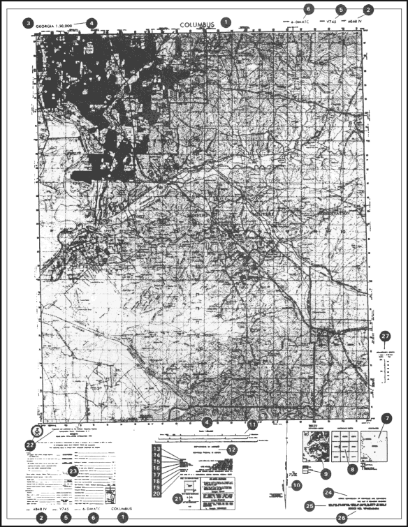
Figure 3-1. Topographical map.
3-2. ADDITIONAL NOTES
Not all maps contain the same items of marginal information. Under certain conditions, special notes and scales may be added to aid the map user. The following are examples:
a. Glossary. This is an explanation of technical terms or a translation of terms on maps of foreign areas where the native language is other than English.
b. Classification. Certain maps require a note indicating the security classification. This is shown in the upper and lower margins.
c. Protractor Scale. This scale may appear in the upper margin on some maps. It is used to lay out the magnetic-grid declination for the map, which, in turn, is used to orient the map sheet with the aid of the lensatic compass.
d. Coverage Diagram. On maps at scales of 1:100,000 and larger, a coverage diagram may be used. It is normally in the lower or right margin and indicates the methods by which the map was made, dates of photography, and reliability of the sources. On maps at 1:250,000 scale, the coverage diagram is replaced by a reliability diagram.
e. Special Notes (24). A special note is any statement of general information that relates to the mapped area. It is normally found in the lower right margin. For example: This map is red-light readable.
f. User’s Note (25). This note is normally located in the lower right-hand margin. It requests cooperation in correcting errors or omissions on the map. Errors should be marked and the map forwarded to the agency identified in the note.
g. Stock Number Identification (26). All maps published by the DMA that are in the Department of the Army map supply system contain stock number identifications that are used in requisitioning map supplies. The identification consists of the words “STOCK NO” followed by a unique designation that is composed of the series number, the sheet number of the individual map and, on recently printed sheets, the edition number. The designation is limited to 15 units (letters and numbers). The first 5 units are allotted to the series number; when the series number is less than 5 units, the letter “X” is substituted as the fifth unit. The sheet number is the next component; however, Roman numerals, which are part of the sheet number, are converted to Arabic numerals in the stock number. The last 2 units are the edition number; the first digit of the edition number is a zero if the number is less than 10. If the current edition number is unknown, the number 01 is used. The latest available edition will be furnished. Asterisks are placed between the sheet number and the edition number when necessary to ensure there are at least 11 units in the stock number.
h. Conversion Graph (27). Normally found in the right margin, this graph indicates the conversion of different units of measure used on the map.
3-3. TOPOGRAPHIC MAP SYMBOLS
The purpose of a map is to permit one to visualize an area of the earth’s surface with pertinent features properly positioned. The map’s legend contains the symbols most commonly used in a particular series or on that specific topographic map sheet. Therefore, the legend should be referred to each time a new map is used. Every effort is made to design standard symbols that resemble the features they represent. If this is not possible, symbols are selected that logically imply the features they portray. For example, an open-pit mining operation is represented by a small black drawing of a crossed hammer and pickax.
a. Ideally, all the features within an area would appear on a map in their true proportion, position, and shape. This, however, is not practical because many of the features would be unimportant and others would be unrecognizable because of their reduction in size.
b. The mapmaker has been forced to use symbols to represent the natural and man-made features of the earth’s surface. These symbols resemble, as closely as possible, the actual features themselves as viewed from above. They are positioned in such a manner that the center of the symbol remains in its true location. An exception to this would be the position of a feature adjacent to a major road. If the width of the road has been exaggerated, then the feature is moved from its true position to preserve its relation to the road. Field Manual 21-31 gives a description of topographic features and abbreviations authorized for use on our military maps.
3-4. MILITARY SYMBOLS
In addition to the topographic symbols used to represent the natural and man-made features of the earth, military personnel require some method for showing identity, size, location, or movement of soldiers; and military activities and installations. The symbols used to represent these military features are known as military symbols. These symbols are not normally printed on maps because the features and units that they represent are constantly moving or changing; military security is also a consideration. They do appear in special maps and overlays (Chapter 7). The map user draws them in, in accordance with proper security precautions. Refer to FM 101-5-1 for complete information on military symbols.
3-5. COLORS USED ON A MILITARY MAP
By the fifteenth century, most European maps were carefully colored. Profile drawings of mountains and hills were shown in brown, rivers and lakes in blue, vegetation in green, roads in yellow, and special information in red. A look at the legend of a modern map confirms that the use of colors has not changed much over the past several hundred years. To facilitate the identification of features on a map, the topographical and cultural information is usually printed in different colors. These colors may vary from map to map. On a standard large-scale topographic map, the colors used and the features each represent are:
a. Black. Indicates cultural (man-made) features such as buildings and roads, surveyed spot elevations, and all labels.
b. Red-Brown. The colors red and brown are combined to identify cultural features, all relief features, non-surveyed spot elevations, and elevation, such as contour lines on red-light readable maps.
c. Blue. Identifies hydrography or water features such as lakes, swamps, rivers, and drainage.
d. Green. Identifies vegetation with military significance, such as woods, orchards, and vineyards.
e. Brown. Identifies all relief features and elevation, such as contours on older edition maps, and cultivated land on red-light readable maps.
f. Red. Classifies cultural features, such as populated areas, main roads, and boundaries, on older maps.
g. Other. Occasionally other colors may be used to show special information. These are indicated in the marginal information as a rule.
Land Navigation Training Software
- Chapter 1: TRAINING STRATEGY
- Chapter 2: MAPS
- Chapter 3: MARGINAL INFORMATION AND SYMBOLS
- Chapter 4: GRIDS
- Chapter 5: SCALE AND DISTANCE
- Chapter 6: DIRECTION
- Chapter 7: OVERLAYS
- Chapter 8: AERIAL PHOTOGRAPHS
- Chapter 9: NAVIGATION EQUIPMENT AND METHODS
- Chapter 10: ELEVATION AND RELIEF
- Chapter 11: TERRAIN ASSOCIATION
- Chapter 12: MOUNTED LAND NAVIGATION
- Chapter 13: NAVIGATION IN DIFFERENT TYPES OF TERRAIN
- Chapter 14: UNIT SUSTAINMENT
- Appendix A: FIELD SKETCHING
- Appendix B: MAP FOLDING TECHNIQUES
- Appendix C: UNITS OF MEASURE AND CONVERSION FACTORS
- Appendix D: JOINT OPERATIONS GRAPHICS
- Appendix E: EXPORTABLE TRAINING MATERIAL
- Appendix F: ORIENTEERING
- Appendix G: M2 COMPASS
- Appendix H: ADDITIONAL AIDS
- Appendix I: FOREIGN MAPS
- Appendix J: GLOBAL POSITIONING SYSTEM
- Appendix K: PRECISION LIGHTWEIGHT GLOBAL POSITIONING SYSTEM RECEIVER
- Map Reading and Land Navigation GLOSSARY
- Map Reading and Land Navigation REFERENCES