Chapter 7
OVERLAYS
An overlay is a clear sheet of plastic or semi-transparent paper. It is used to display supplemental map and tactical information related to military operations. It is often used as a supplement to orders given in the field. Information is plotted on the overlay at the same scale as on the map, aerial photograph, or other graphic being used. When the overlay is placed over the graphic, the details plotted on the overlay are shown in their true position.
7-1. PURPOSE
Overlays are used to display military operations with enemy and friendly troop dispositions, and as supplements to orders sent to the field. They show detail that will aid in understanding the orders, displays of communication networks, and so forth. They are also used as annexes to reports made in the field because they can clarify matters that are difficult to explain clearly in writing.
7-2. MAP OVERLAY
There are three steps in the making of a map overlay—orienting the overlay material, plotting and symbolizing the detail, and adding the required marginal information (Figure 7-1).
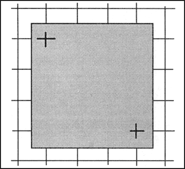
Figure 7-1. Registering the overlay.
a. Orienting. Orient the overlay over the place on the map to be annotated. Then, if possible, attach it to the edges of the map with tape. Trace the grid intersections nearest the two opposite corners of the overlay using a straightedge and label each with the proper grid coordinates. These register marks show the receiver of your overlay exactly where it fits on his map; without them, the overlay is difficult to orient. It is imperative that absolute accuracy be maintained in plotting the register marks, as the smallest mistake will throw off the overlay.
b. Plotting of New Detail. Use pencils or markers in standard colors that make a lasting mark without cutting the overlay to plot any detail (FM 101-5-1).
(1) Use standard topographic or military symbols where possible. Nonstandard symbols invented by the author must be identified in a legend on the overlay. Depending on the conditions under which the overlay is made, it may be advisable to plot the positions first on the map, then trace them onto the overlay. Since the overlay is to be used as a supplement to orders or reports and the recipient will have an identical map, show only that detail with which the report is directly concerned.
(2) If you have observed any topographic or cultural features that are not shown on the map, such as a new road or a destroyed bridge, plot their positions as accurately as possible on the overlay and mark with the standard topographic symbol.
(3) If difficulty in seeing through the overlay material is encountered while plotting or tracing detail, lift the overlay from time to time to check orientation of information being added in reference to the base.
c. Recording Marginal Information. When all required detail has been plotted or traced on the overlay, print information as close to the lower right-hand corner as detail permits (Figure 7-2). This information includes the following data:
(1) Title and Objective. This tells the reader why the overlay was made and may also give the actual location. For example, “Road Reconnaissance” is not as specific as “Route 146 Road Reconnaissance.”
(2) Time and Date. Any overlay should contain the latest possible information. An overlay received in time is very valuable to the planning staff and may affect the entire situation; an overlay that has been delayed for any reason may be of little use. Therefore, the exact time the information was obtained aids the receivers in determining its reliability and usefulness.
(3) Map Reference. The sheet name, sheet number, map series number, and scale must be included. If the reader does not have the map used for the overlay, this provides the information necessary to obtain it.
(4) Author. The name, rank, and organization of the author, supplemented with a date and time of preparation of the overlay, tells the reader if there was a time difference between when the information was obtained and when it was reported.
(5) Legend. If it is necessary to invent nonstandard symbols to show the required information, the legend must show what these symbols mean.
(6) Security Classification. This must correspond to the highest classification of either the map or the information placed on the overlay. If the information and map are unclassified, this will be so stated. The locations of the classification notes are shown in Figure 7-2, and the notes will appear in both locations as shown.
(7) Additional Information. Any other information that amplifies the overlay will also be included. Make it as brief as possible.
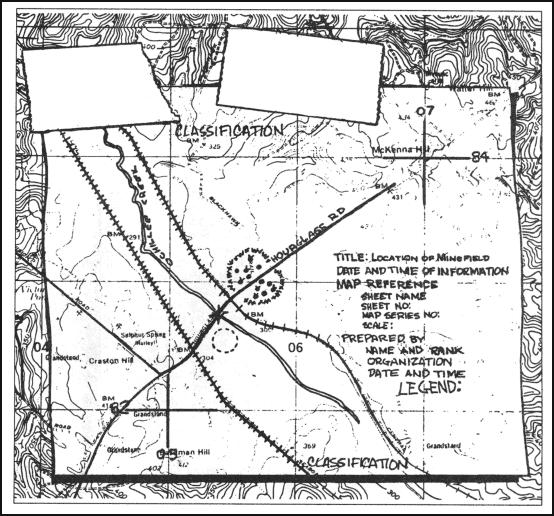
Figure 7-2. Map overlay with marginal information.
7-3. AERIAL PHOTOGRAPH OVERLAY
Overlays of single aerial photographs are constructed and used in the same way as map overlays. The steps followed are essentially the same, with the following exceptions:
a. Orienting of Overlay. The photograph normally does not have grid lines to be used as register marks. The borders of the photograph limit the area of the overlay, so the reference marks or linear features are traced in place of grid register marks. Finally, to ensure proper location of the overlay with respect to the photograph, indicate on the overlay the position of the marginal data on the photograph as seen through the overlay.
b. Marginal Information. The marginal information shown on photographs varies somewhat from that shown on maps. Overlays of photographs (Figure 7-3) should show the following information:
(1) North Arrow. This may be obtained in two ways—by comparing with a map of the area or by orienting the photograph by inspection. In the latter case, a compass or expedient direction finder must be used to place the direction arrow on the overlay. Use the standard symbol to represent the actual north arrow used—grid, magnetic, or true north.
(2) Title and Objective. This tells the reader why the photo overlay was made and may also give the actual location.
(3) Time and Date. The exact time the information was obtained is shown on a photo overlay just as on a map overlay
(4) Photo Reference. The photo number, mission number, date of flight, and scale appear here, or the information is traced in its actual location on the photograph.
(5) Scale. The scale must be computed since it is not part of the marginal data.
(6) Map Reference. Reference is made to the sheet name, sheet number, series number, and scale of a map of the area, if one is available.
(7) Author. The name, rank, and organization of the author are shown, supplemented with a date and time of preparation of the overlay.
(8) Legend. As with map overlays, this is only necessary when nonstandard symbols are used.
(9) Security Classification. This must correspond to the highest classification of either the photograph or the information placed on the overlay. If the information and photograph are unclassified, this will be so stated. The locations of the classification notes are shown in Figure 7-3, and the notes will appear in both locations.
(10) Additional Information. Any other information that amplifies the overlay will also be included. Make it as brief as possible.
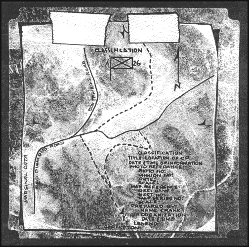
Figure 7-3. Photographic overlay with marginal information.
Land Navigation Training Software
- Chapter 1: TRAINING STRATEGY
- Chapter 2: MAPS
- Chapter 3: MARGINAL INFORMATION AND SYMBOLS
- Chapter 4: GRIDS
- Chapter 5: SCALE AND DISTANCE
- Chapter 6: DIRECTION
- Chapter 7: OVERLAYS
- Chapter 8: AERIAL PHOTOGRAPHS
- Chapter 9: NAVIGATION EQUIPMENT AND METHODS
- Chapter 10: ELEVATION AND RELIEF
- Chapter 11: TERRAIN ASSOCIATION
- Chapter 12: MOUNTED LAND NAVIGATION
- Chapter 13: NAVIGATION IN DIFFERENT TYPES OF TERRAIN
- Chapter 14: UNIT SUSTAINMENT
- Appendix A: FIELD SKETCHING
- Appendix B: MAP FOLDING TECHNIQUES
- Appendix C: UNITS OF MEASURE AND CONVERSION FACTORS
- Appendix D: JOINT OPERATIONS GRAPHICS
- Appendix E: EXPORTABLE TRAINING MATERIAL
- Appendix F: ORIENTEERING
- Appendix G: M2 COMPASS
- Appendix H: ADDITIONAL AIDS
- Appendix I: FOREIGN MAPS
- Appendix J: GLOBAL POSITIONING SYSTEM
- Appendix K: PRECISION LIGHTWEIGHT GLOBAL POSITIONING SYSTEM RECEIVER
- Map Reading and Land Navigation GLOSSARY
- Map Reading and Land Navigation REFERENCES