Chapter 10
ELEVATION AND RELIEF
The elevation of points on the ground and the relief of an area affect the movement, positioning, and, in some cases, effectiveness of military units. Soldiers must know how to determine locations of points on a map, measure distances and azimuths, and identify symbols on a map. They must also be able to determine the elevation and relief of areas on standard military maps. To do this, they must first understand how the mapmaker indicated the elevation and relief on the map.
10-1. DEFINITIONS
The reference or start point for vertical measurement of elevation on a standard military map are the datum plane or mean sea level, the point halfway between high tide and low tide. Elevation of a point on the earth’s surface is the vertical distance it is above or below mean sea level. Relief is the representation (as depicted by the mapmaker) of the shapes of hills, valleys, streams, or terrain features on the earth’s surface.
10-2. METHODS OF DEPICTING RELIEF
Mapmakers use several methods to depict relief of the terrain.
a. Layer Tinting. Layer tinting is a method of showing relief by color. A different color is used for each band of elevation. Each shade of color, or band, represents a definite elevation range. A legend is printed on the map margin to indicate the elevation range represented by each color. However, this method does not allow the map user to determine the exact elevation of a specific point—only the range.
b. Form Lines. Form lines are not measured from any datum plane. Form lines have no standard elevation and give only a general idea of relief. Form lines are represented on a map as dashed lines and are never labeled with representative elevations.
c. Shaded Relief. Relief shading indicates relief by a shadow effect achieved by tone and color that results in the darkening of one side of terrain features, such as hills and ridges. The darker the shading, the steeper the slope. Shaded relief is sometimes used in conjunction with contour lines to emphasize these features.
d. Hachures. Hachures are short, broken lines used to show relief. Hachures are sometimes used with contour lines. They do not represent exact elevations, but are mainly used to show large, rocky outcrop areas. Hachures are used extensively on small-scale maps to show mountain ranges, plateaus, and mountain peaks.
e. Contour Lines. Contour lines are the most common method of showing relief and elevation on a standard topographic map. A contour line represents an imaginary line on the ground, above or below sea level. All points on the contour line are at the same elevation. The elevation represented by contour lines is the vertical distance above or below sea level. The three types of contour lines (Figure 10-1) used on a standard topographic map are as follows:
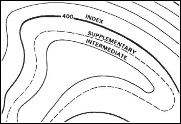
Figure 10-1. Contour lines.
(1) Index. Starting at zero elevation or mean sea level, every fifth contour line is a heavier line. These are known as index contour lines. Normally, each index contour line is numbered at some point. This number is the elevation of that line.
(2) Intermediate. The contour lines falling between the index contour lines are called intermediate contour lines. These lines are finer and do not have their elevations given. There are normally four intermediate contour lines between index contour lines.
(3) Supplementary. These contour lines resemble dashes. They show changes in elevation of at least one-half the contour interval. These lines are normally found where there is very little change in elevation, such as on fairly level terrain.
10-3. CONTOUR INTERVALS
Before the elevation of any point on the map can be determined, the user must know the contour interval for the map he is using. The contour interval measurement given in the marginal information is the vertical distance between adjacent contour lines. To determine the elevation of a point on the map—
a. Determine the contour interval and the unit of measure used, for example, feet, meters, or yards (Figure 10-2).
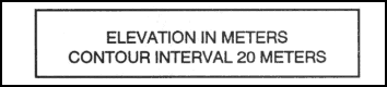
Figure 10-2. Contour interval note.
b. Find the numbered index contour line nearest the point of which you are trying to determine the elevation (Figure 10-3).
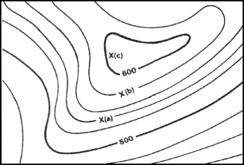
Figure 10-3. Points on contour lines.
c. Determine if you are going from lower elevation to higher, or vice versa. In Figure 10-3, point (a) is between the index contour lines. The lower index contour line is numbered 500, which means any point on that line is at an elevation of 500 meters above mean sea level. The upper index contour line is numbered 600, or 600 meters. Going from the lower to the upper index contour line shows an increase in elevation.
d. Determine the exact elevation of point (a), start at the index contour line numbered 500 and count the number of intermediate contour lines to point (a). Locate point (a) on the second intermediate contour line above the 500-meter index contour line. The contour interval is 20 meters (Figure 10-2), thus each one of the intermediate contour lines crossed to get to point (a) adds 20 meters to the 500-meter index contour line. The elevation of point (a) is 540 meters; the elevation has increased.
e. Determine the elevation of point (b). Go to the nearest index contour line. In this case, it is the upper index contour line numbered 600. Locate point (b) on the intermediate contour line immediately below the 600-meter index contour line. Below means downhill or a lower elevation. Therefore, point (b) is located at an elevation of 580 meters. Remember, if you are increasing elevation, add the contour interval to the nearest index contour line. If you are decreasing elevation, subtract the contour interval from the nearest index contour line.
f. Determine the elevation to a hilltop point (c). Add one-half the contour interval to the elevation of the last contour line. In this example, the last contour line before the hilltop is an index contour line numbered 600. Add one-half the contour interval, 10 meters, to the index contour line. The elevation of the hilltop would be 610 meters.
g. There may be times when you need to determine the elevation of points to a greater accuracy. To do this, you must determine how far between the two contour lines the point lies. However, most military needs are satisfied by estimating the elevation of points between contour lines (Figure 10-4).
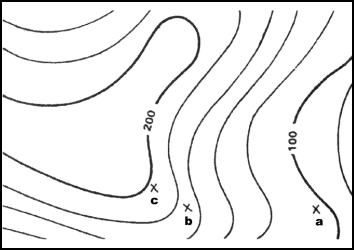
Figure 10-4. Points between contour lines.
(1) If the point is less than one-fourth the distance between contour lines, the elevation will be the same as the last contour line. In Figure 10-4, the elevation of point a will be 100 meters. To estimate the elevation of a point between one-fourth and three-fourths of the distance between contour lines, add one-half the contour interval to the last contour line.
(2) Point b is one-half the distance between contour lines. The contour line immediately below point b is at an elevation of 160 meters. The contour interval is 20 meters; thus one-half the contour interval is 10 meters. In this case, add 10 meters to the last contour line of 160 meters. The elevation of point b would be about 170 meters.
(3) A point located more than three-fourths of the distance between contour lines is considered to be at the same elevation as the next contour line. Point c is located three-fourths of the distance between contour lines. In Figure 10-4, point c would be considered to be at an elevation of 180 meters.
h. To estimate the elevation to the bottom of a depression, subtract one-half the contour interval from the value of the lowest contour line before the depression. In Figure 10-5, the lowest contour line before the depression is 240 meters in elevation. Thus, the elevation at the edge of the depression is 240 meters. To determine the elevation at the bottom of the depression, subtract one-half the contour interval. The contour interval for this example is 20 meters. Subtract 10 meters from the lowest contour line immediately before the depression. The result is that the elevation at the bottom of the depression is 230 meters. The tick marks on the contour line forming a depression always point to lower elevations.
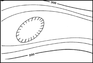
Figure 10-5. Depression.
i. In addition to the contour lines, bench marks and spot elevations are used to indicate points of known elevations on the map.
(1) Bench marks, the more accurate of the two, are symbolized by a black X, such as X BM 214. The 214 indicates that the center of the X is at an elevation of 214 units of measure (feet, meters, or yards) above mean sea level. To determine the units of measure, refer to the contour interval in the marginal information.
(2) Spot elevations are shown by a brown X and are usually located at road junctions and on hilltops and other prominent terrain features. If the elevation is shown in black numerals, it has been checked for accuracy; if it is in brown, it has not been checked.
NOTE:
10-4. TYPES OF SLOPES
Depending on the military mission, soldiers may need to determine not only the height of a hill, but the degree of the hill’s slope as well. The rate of rise or fall of a terrain feature is known as its slope. The speed at which equipment or personnel can move is affected by the slope of the ground or terrain feature. This slope can be determined from the map by studying the contour lines—the closer the contour lines, the steeper the slope; the farther apart the contour lines, the gentler the slope. Four types of slopes that concern the military are as follows:
a. Gentle. Contour lines showing a uniform, gentle slope will be evenly spaced and wide apart (Figure 10-6). Considering relief only, a uniform, gentle slope allows the defender to use grazing fire. The attacking force has to climb a slight incline.
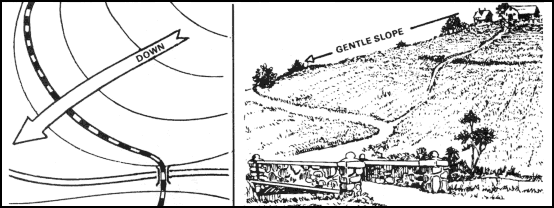
Figure 10-6. Uniform, gentle slope.
b. Steep. Contour lines showing a uniform, steep slope on a map will be evenly spaced, but close together. Remember, the closer the contour lines, the steeper the slope (Figure 10-7). Considering relief only, a uniform, steep slope allows the defender to use grazing fire, and the attacking force has to negotiate a steep incline.
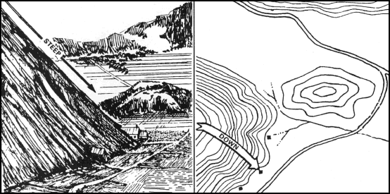
Figure 10-7. Uniform, steep slope.
c. Concave. Contour lines showing a concave slope on a map will be closely spaced at the top of the terrain feature and widely spaced at the bottom (Figure 10-8). Considering relief only, the defender at the top of the slope can observe the entire slope and the terrain at the bottom, but he cannot use grazing fire. The attacker would have no cover from the defender’s observation of fire, and his climb would become more difficult as he got farther up the slope.
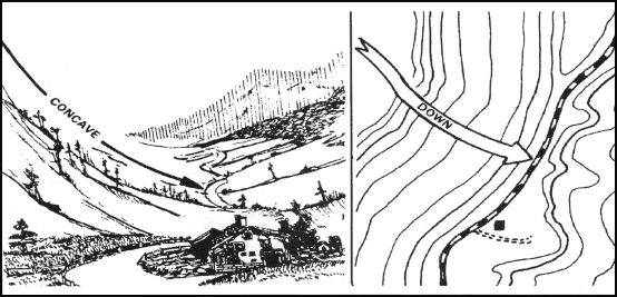
Figure 10-8. Concave slope.
d. Convex. Contour lines showing a convex slope on a map will be widely spaced at the top and closely spaced at the bottom (Figure 10-9). Considering relief only, the defender at the top of the convex slope can obtain a small distance of grazing fire, but he cannot observe most of the slope or the terrain at the bottom. The attacker will have concealment on most of the slope and an easier climb as he nears the top.
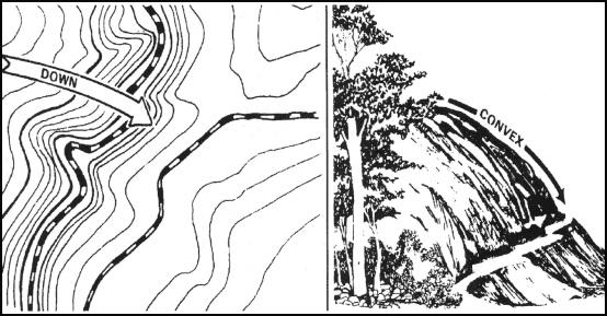
Figure 10-9. Convex slope.
10-5. PERCENTAGE OF SLOPE
The speed at which personnel and equipment can move up or down a hill is affected by the slope of the ground and the limitations of the equipment. Because of this, a more exact way of describing a slope is necessary.
a. Slope may be expressed in several ways, but all depend upon the comparison of vertical distance (VD) to horizontal distance (HD) (Figure 10-10). Before we can determine the percentage of a slope, we must know the VD of the slope. The VD is determined by subtracting the lowest point of the slope from the highest point. Use the contour lines to determine the highest and lowest point of the slope (Figure 10-11).
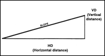
Figure 10-10. Slope diagram.
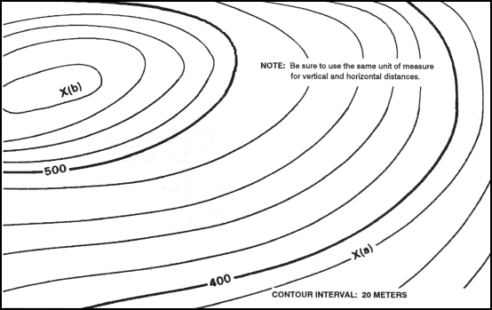
Figure 10-11. Contour line around a slope.
b. To determine the percentage of the slope between points (a) and (b) in Figure 10-11, determine the elevation of point (b) (590 meters). Then determine the elevation of point (a) (380 meters). Determine the vertical distance between the two points by subtracting the elevation of point (a) from the elevation of point .The difference (210 meters) is the VD between points (a) and (b). Then measure the HD between the two points on the map in Figure 10-12. After the horizontal distance has been determined, compute the percentage of the slope by using the formula shown in Figure 10-13.
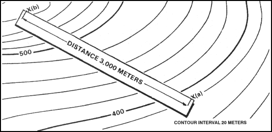
Figure 10-12. Measuring horizontal distance.
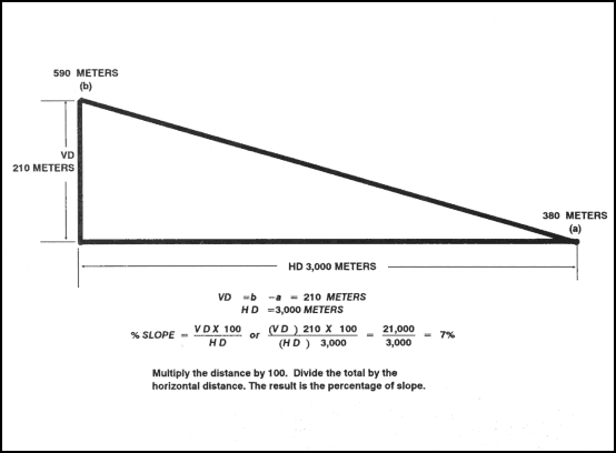
Figure 10-13. Percentage of slope in meters.
c. The slope angle can also be expressed in degrees. To do this, determine the VD and HD of the slope. Multiply the VD by 57.3 and then divide the total by the HD (Figure 10-14). This method determines the approximate degree of slope and is reasonably accurate for slope angles less than 20º.
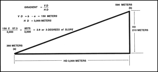
Figure 10-14. Degree of slope.
d. The slope angle can also be expressed as a gradient. The relationship of horizontal and vertical distance is expressed as a fraction with a numerator of one (Figure 10-15).
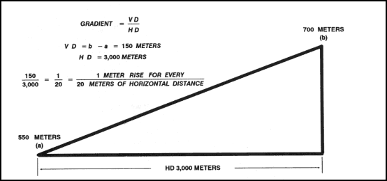
Figure 10-15. Gradient.
10-6. TERRAIN FEATURES
All terrain features are derived from a complex landmass known as a mountain or ridgeline (Figure 10-16). The term ridgeline is not interchangeable with the term ridge. A ridgeline is a line of high ground, usually with changes in elevation along its top and low ground on all sides from which a total of 10 natural or man-made terrain features are classified.
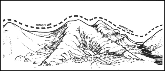
Figure 10-16. Ridgeline.
a. Major Terrain Features.
(1) Hill. A hill is an area of high ground. From a hilltop, the ground slopes down in all directions. A hill is shown on a map by contour lines forming concentric circles. The inside of the smallest closed circle is the hilltop (Figure 10-17).
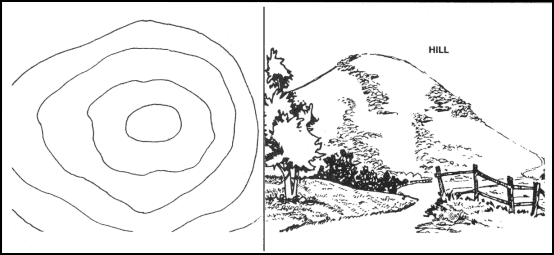
Figure 10-17. Hill.
(2) Saddle. A saddle is a dip or low point between two areas of higher ground. A saddle is not necessarily the lower ground between two hilltops; it may be simply a dip or break along a level ridge crest. If you are in a saddle, there is high ground in two opposite directions and lower ground in the other two directions. A saddle is normally represented as an hourglass (Figure 10-18).
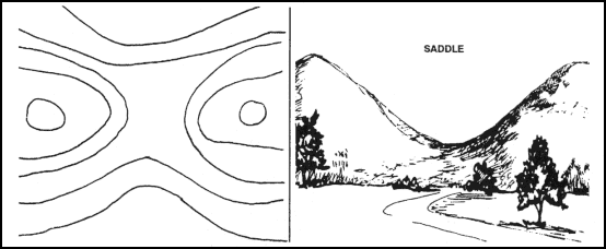
Figure 10-18. Saddle.
(3) Valley. A valley is a stretched-out groove in the land, usually formed by streams or rivers. A valley begins with high ground on three sides, and usually has a course of running water through it. If standing in a valley, three directions offer high ground, while the fourth direction offers low ground. Depending on its size and where a person is standing, it may not be obvious that there is high ground in the third direction, but water flows from higher to lower ground. Contour lines forming a valley are either U-shaped or V-shaped. To determine the direction water is flowing, look at the contour lines. The closed end of the contour line (U or V) always points upstream or toward high ground (Figure 10-19).
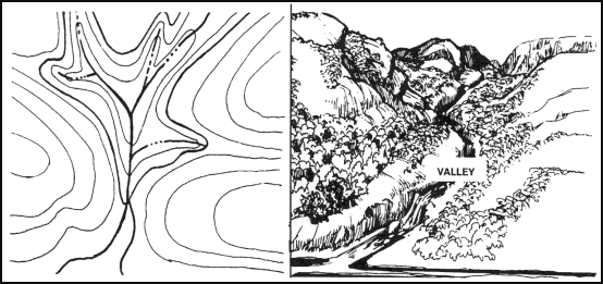
Figure 10-19. Valley.
(4) Ridge. A ridge is a sloping line of high ground. If you are standing on the centerline of a ridge, you will normally have low ground in three directions and high ground in one direction with varying degrees of slope. If you cross a ridge at right angles, you will climb steeply to the crest and then descend steeply to the base. When you move along the path of the ridge, depending on the geographic location, there may be either an almost unnoticeable slope or a very obvious incline. Contour lines forming a ridge tend to be U-shaped or V-shaped. The closed end of the contour line points away from high ground (Figure 10-20).
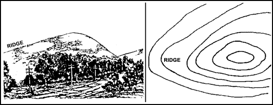
Figure 10-20. Ridge.
(5) Depression. A depression is a low point in the ground or a sinkhole. It could be described as an area of low ground surrounded by higher ground in all directions, or simply a hole in the ground. Usually only depressions that are equal to or greater than the contour interval will be shown. On maps, depressions are represented by closed contour lines that have tick marks pointing toward low ground (Figure 10-21).
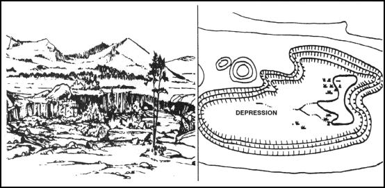
Figure 10-21. Depression.
b. Minor Terrain Features.
(1) Draw. A draw is a less developed stream course than a valley. In a draw, there is essentially no level ground and, therefore, little or no maneuver room within its confines. If you are standing in a draw, the ground slopes upward in three directions and downward in the other direction. A draw could be considered as the initial formation of a valley. The contour lines depicting a draw are U-shaped or V-shaped, pointing toward high ground (Figure 10-22).
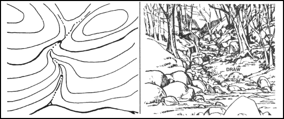
Figure 10-22. Draw.
(2) Spur. A spur is a short, continuous sloping line of higher ground, normally jutting out from the side of a ridge. A spur is often formed by two rough parallel streams, which cut draws down the side of a ridge. The ground sloped down in three directions and up in one direction. Contour lines on a map depict a spur with the U or V pointing away from high ground (Figure 10-23).
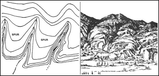
Figure 10-23. Spur.
(3) Cliff. A cliff is a vertical or near vertical feature; it is an abrupt change of the land. When a slope is so steep that the contour lines converge into one “carrying” contour of contours, this last contour line has tick marks pointing toward low ground (Figure 10-24A). Cliffs are also shown by contour lines very close together and, in some instances, touching each other (Figure 10-24B).
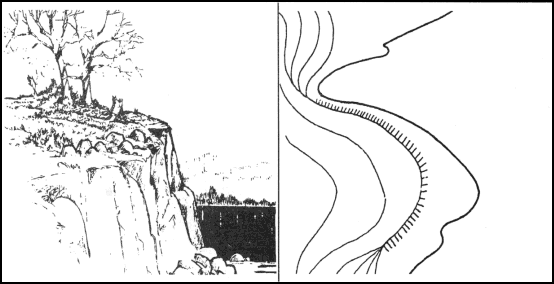
Figure 10-24A. Cliff.
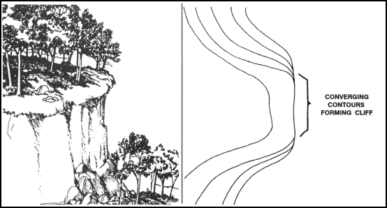
Figure 10-24B. Cliff.
c. Supplementary Terrain Features.
(1) Cut. A cut is a man-made feature resulting from cutting through raised ground, usually to form a level bed for a road or railroad track. Cuts are shown on a map when they are at least 10 feet high, and they are drawn with a contour line along the cut line. This contour line extends the length of the cut and has tick marks that extend from the cut line to the roadbed, if the map scale permits this level of detail (Figure 10-25).
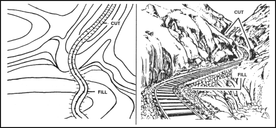
Figure 10-25. Cut and fill.
(2) Fill. A fill is a man-made feature resulting from filling a low area, usually to form a level bed for a road or railroad track. Fills are shown on a map when they are at least 10 feet high, and they are drawn with a contour line along the fill line. This contour line extends the length of the filled area and has tick marks that point toward lower ground. If the map scale permits, the length of the fill tick marks are drawn to scale and extend from the base line of the fill symbol (Figure 10-25).
10-7. INTERPRETATION OF TERRAIN FEATURES
Terrain features do not normally stand a lone. To better understand these when they are depicted on a map, you need to interpret them. Terrain features (Figure 10-26) are interpreted by using contour lines, the SOSES approach, ridgelining, or streamlining.
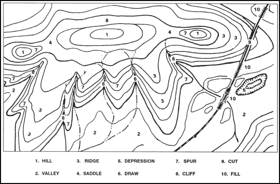
Figure 10-26. Terrain features.
a. Contour Lines. Emphasizing the main contour lines is a technique used to interpret the terrain of an area. By studying these contour lines, you able to obtain a better understanding of the layout of the terrain and to decide on the best route.
(1) The following description pertains to Figure 10-27. Running east to west across the complex landmass is a ridgeline. A ridgeline is a line of high ground, usually with changes in elevation along its top and low ground on all sides. The changes in elevation are the three hilltops and two saddles along the ridgeline. From the top of each hill, there is lower ground in all directions. The saddles have lower ground in two directions and high ground in the opposite two directions. The contour lines of each saddle form half an hourglass shape. Because of the difference in size of the higher ground on the two opposite sides of a saddle, a full hourglass shape of a saddle may not be apparent.
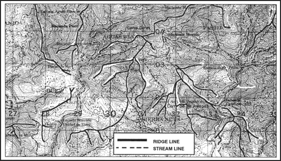
Figure 10-27. Ridgelining and streamlining.
(2) There are four prominent ridges. A ridge is on each end of the ridgeline and two ridges extend south from the ridgeline. All of the ridges have lower ground in three directions and higher ground in one direction. The closed ends of the U’s formed by the contour lines point away from higher ground.
(3) To the south lies a valley; the valley slopes downward from east to west. Note that the U of the contour line points to the east, indicating higher ground in that direction and lower ground to the west. Another look at the valley shows high ground to the north and south of the valley.
(4) Just east of the valley is a depression. There is higher ground in all directions when looking from the bottom of the depression.
(5) There are several spurs extending generally south from the ridgeline. They, like ridges, have lower ground in three directions and higher ground in one direction. Their contour line U’s point away from higher ground.
(6) Between the ridges and spurs are draws. They, like valleys, have higher ground in three directions and lower ground in one direction. Their contour line U’s and V’s point toward higher ground.
(7) Two contour lines on the north side of the center hill are touching or almost touching. They have ticks indicating a vertical or nearly vertical slope or a cliff.
(8) The road cutting through the eastern ridge depicts cuts and fills. The breaks in the contour lines indicate cuts, and the ticks pointing away from the roadbed on each side of the road indicate fills.
b. SOSES. A recommended technique for identifying specific terrain features and then locating them on the map is to make use of five of their characteristics known by the mnemonic SOSES. Terrain features can be examined, described, and compared with each other and with corresponding map contour patterns in terms of their shapes, orientations, sizes, elevations, and slopes.
(1) Shape. The general form or outline of the feature at its base.
(2) Orientation. The general trend or direction of a feature from your viewpoint. A feature can be in line, across, or at an angle to your viewpoint.
(3) Size. The length or width of a feature horizontally across its base. For example, one terrain feature might be larger or smaller than another terrain feature.
(4) Elevation. The height of a terrain feature. This can be described either in absolute or relative terms as compared to the other features in the area. One landform may be higher, lower, deeper, or shallower than another.
(5) Slope. The type (uniform, convex, or concave) and the steepness or angle (steep or gentle) of the sides of a terrain feature.
Through practice, you can learn to identify several individual terrain features in the field and see how they vary in appearance.
NOTE:
c. Ridgelining. This technique helps you to visualize the overall lay of the ground within the area of interest on the map. Follow these steps:
(1) Identify on the map the crests of the ridgelines in your area of operation by identifying the close-out contours that lie along the hilltop.
(2) Trace over the crests so each ridgeline stands out clearly as one identifiable line.
(3) Go back over each of the major ridgelines and trace over the prominent ridges and spurs that come out of the ridgelines.
The usual colors used for this tracing are red or brown; however, you may use any color at hand. When you have completed the ridgelining process, you will find that the high ground on the map will stand out and that you will be able to see the relationship between the various ridgelines (Figure 10-27).
d. Streamlining. This procedure (Figure 10-27) is similar to that of ridgelining.
(1) Identify all the mapped streams in the area of operations.
(2) Trace over them to make them stand out more prominently.
(3) Then identify other low ground, such as smaller valleys or draws that feed into the major streams, and trace over them.
This brings out the drainage pattern and low ground in the area of operation on the map. The color used for this is usually blue; but again, if blue is not available, use any color at hand so long as the distinction between the ridgelines and the streamlines is clear.
10-8. PROFILES
The study of contour lines to determine high and low points of elevation is usually adequate for military operations. However, there may be a few times when we need a quick and precise reference to determine exact elevations of specific points. When exactness is demanded, a profile is required. A profile, within the scope and purpose of this manual, is an exaggerated side view of a portion of the earth’s surface along a line between two or more points.
a. A profile can be used for many purposes. The primary purpose is to determine if line of sight is available. Line of sight is used—
(1) To determine defilade positions.
(2) To plot hidden areas or dead space.
(3) To determine potential direct fire weapon positions.
(4) To determine potential locations for defensive positions.
(5) To conduct preliminary planning in locating roads, pipelines, railroads, or other construction projects.
b. A profile can be constructed from any contoured map. Its construction requires the following steps:
(1) Draw a line on the map from where the profile is to begin to where it is to end (Figure 10-28).
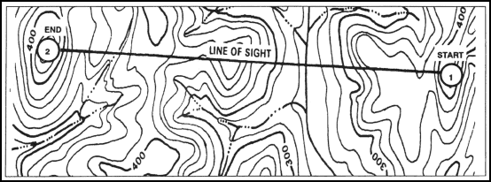
Figure 10-28. Connecting points.
(2) Find the value of the highest and lowest contour lines that cross or touch the profile line. Add one contour value above the highest and one below the lowest to take care of hills and valleys.
(3) Select a piece of lined notebook paper with as many lines as was determined in (2) above. The standard Army green pocket notebook or any other paper with 1/4-inch lines is ideal. Wider lines, up to 5/8-inch, may be used. If lined paper is not available, draw equally spaced horizontal lines on a blank sheet of paper.
(4) Number the top line with the highest value and the bottom line with the lowest value as determined in (2) above.
(5) Number the rest of the lines in sequence, starting with the second line from the top. The lines will be numbered in accordance with the contour interval (Figure 10-29).
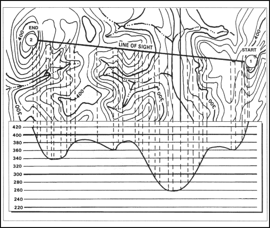
Figure 10-29. Dropping perpendiculars.
(6) Place the paper on the map with the lines next to and parallel to the profile line (Figure 10-29).
(7) From every point on the profile line where a contour line, stream, intermittent stream, or other body of water crosses or touches, drop a perpendicular line to the line having the same value. Place a tick mark where the perpendicular line crosses the number line (Figure 10-29). Where trees are present, add the height of the trees to the contour line and place a tick mark there. Assume the height of the trees to be 50 feet or 15 meters where dark green tint is shown on the map. Vegetation height may be adjusted up or down when operations in the area have provided known tree heights.
(8) After all perpendicular lines have been drawn and tick marks placed where the lines cross, connect all tick marks with a smooth, natural curve to form a horizontal view or profile of the terrain along the profile line (Figure 10-29).
NOTE:
(9) Draw a straight line from the start point to the end point on the profile. If the straight line intersects the curved profile, line of sight to the end point is not available (Figure 10-30).
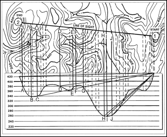
Figure 10-30. Drawing lines to additional points.
(10) Determine the line of sight to other points along the profile line by drawing a line from the start point to additional points. In Figure 10-31, line of sight is available to—
A—Yes
D—Yes
G—Yes
B—No
E—No
H—No
C—No
F—No
I—No
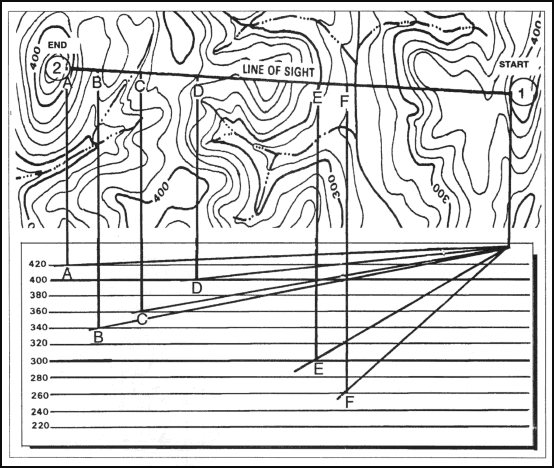
Figure 10-31. Drawing a hasty profile.
The vertical distance between navigable ground up to the line of sight line is the depth of defilade.
c. When time is short, or when a complete profile is not needed, one may be constructed showing only the hilltops, ridges, and if desired, the valleys. This is called a hasty profile. It is constructed in the same manner as a full profile (Figure 10-31).
Land Navigation Training Software
- Chapter 1: TRAINING STRATEGY
- Chapter 2: MAPS
- Chapter 3: MARGINAL INFORMATION AND SYMBOLS
- Chapter 4: GRIDS
- Chapter 5: SCALE AND DISTANCE
- Chapter 6: DIRECTION
- Chapter 7: OVERLAYS
- Chapter 8: AERIAL PHOTOGRAPHS
- Chapter 9: NAVIGATION EQUIPMENT AND METHODS
- Chapter 10: ELEVATION AND RELIEF
- Chapter 11: TERRAIN ASSOCIATION
- Chapter 12: MOUNTED LAND NAVIGATION
- Chapter 13: NAVIGATION IN DIFFERENT TYPES OF TERRAIN
- Chapter 14: UNIT SUSTAINMENT
- Appendix A: FIELD SKETCHING
- Appendix B: MAP FOLDING TECHNIQUES
- Appendix C: UNITS OF MEASURE AND CONVERSION FACTORS
- Appendix D: JOINT OPERATIONS GRAPHICS
- Appendix E: EXPORTABLE TRAINING MATERIAL
- Appendix F: ORIENTEERING
- Appendix G: M2 COMPASS
- Appendix H: ADDITIONAL AIDS
- Appendix I: FOREIGN MAPS
- Appendix J: GLOBAL POSITIONING SYSTEM
- Appendix K: PRECISION LIGHTWEIGHT GLOBAL POSITIONING SYSTEM RECEIVER
- Map Reading and Land Navigation GLOSSARY
- Map Reading and Land Navigation REFERENCES