Chapter 13
NAVIGATION IN DIFFERENT TYPES OF TERRAIN
The information, concepts, and skills already presented will help you to navigate anywhere in the world; however, there are some special considerations and helpful hints that may assist you in various special environments. The following information is not doctrine.
13-1. DESERT TERRAIN
About 5 percent of the earth’s land surface is covered by deserts (Figure 13-1). Deserts are large arid areas with little or no rainfall during the year. There are three types of deserts—mountain, rocky plateau, and sandy or dune deserts. All types of forces can be deployed in the desert. Armor and mechanized infantry forces are especially suitable to desert combat except in rough mountainous terrain where light infantry may be required. Airborne, air assault, and motorized forces can also be advantageously employed to exploit the vast distances characteristic of desert warfare.
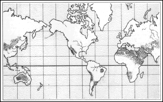
Figure 13-1. Deserts.
a. Desert Regions. In desert regions, terrain varies from nearly flat to lava beds and salt marshes. Mountain deserts contain scattered ranges or areas of barren hills or mountains. Table 13-1 lists some of the world’s major desert regions and their locations.
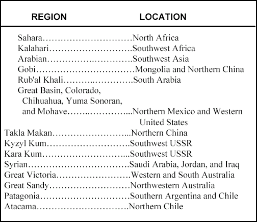
Table 13-1. Major desert regions.
(1) Finding the way in a desert presents some degree of difficulty for a person who has never been exposed to this environment. Desert navigators have learned their way through generations of experience.
(2) Normally, desert people are nomadic, constantly moving in caravans. Navigating becomes second nature to them. Temperature in the tropical deserts reaches an average of 110° to 115° during the day, so most navigation takes place at night using the stars. Most deserts have some prevailing winds during the seasons. Such winds arrange the sand dunes in a specific pattern that gives the navigator the opportunity to determine the four cardinal directions. He may also use the sun’s shadow-tip method.
(3) A sense of direction can be obtained by watching desert animals on their way to and from water holes (oases). Water, navigation, and survival are closely related in desert areas. Most deserts have pigeons or doves, and their drinking habits are important to the navigator. As a rule, these birds never drink in the morning or during the day, making their evening flights the most important. When returning from the oases, their bodies are heavier from drinking and their flight is accompanied by a louder flapping of their wings.
(4) Visibility is also an important factor in the desert, especially in judging distance. The absence of trees or other features prevents comparison between the horizon and the skyline.
b. Interpretation and Analysis. Many desert maps are inaccurate, which makes up-to-date air, aerial photo, and ground reconnaissance necessary. In desert mountain areas contour intervals are generally large, so many of the intermediate relief features are not shown.
(1) The desert normally permits observation and fire to maximum ranges. The terrain is generally wide open and the exceptionally clear atmosphere offers excellent long-range visibility. Combine this with a powerful sun and low cloud density and you have nearly unlimited light and visual clarity, which often contribute to gross underestimations of ranges. Errors of up to 200 or 300 percent are not uncommon. However, visibility conditions may be severely affected by sandstorms and mirages (heat shimmer caused by air rising from the extremely hot daytime desert surface), especially if the observer is looking into the sun through magnifying optical instruments.
(2) Cover can be provided only by terrain feature masking because of the lack of heavy vegetation and man-made objects. It only takes a few meters of relief to provide cover. Concealment in the desert is related to the following factors:
(a) Shape. In order not to be observed by the enemy, attempt to alter the standard shapes of vehicles so they and their shadows are not instantly recognized.
(b) Shine. Shine or glitter is often the first thing that attracts the observer’s eye to movement many kilometers away. It must be eliminated.
(c) Color and texture. All equipment should either be pattern painted or mudded to blend in with the terrain.
(d) Light and noise. Light and noise discipline are essential because sound and light travel great distances in the desert.
(e) Heat. Modern heat image technology makes shielding heat sources an important consideration when trying to hide from the enemy. This technology is especially important during night stops.
(f) Movement. Movement itself creates a great deal of noise and dust, but a rapid execution using all the advantages the topography offers can help conceal it.
c. Navigation. When operating in the broad basins between mountain ranges or on rocky plateau deserts, there are frequently many terrain features to guide your movement by. But, observing these known features over great distances may provide a false sense of security in determining your precise location unless you frequently confirm your location by resection or referencing close-in terrain features. It is not uncommon to develop errors of several kilometers when casually estimating a position in this manner. Obviously, this can create many problems when attempting to locate a small checkpoint or objective, calling for CAS, reporting operational or intelligence information, or meeting CSS requirements.
(1) When operating in an area with few visual cues, such as in a sandy or dune desert, or restricted visibility by a sandstorm or darkness, you must proceed by dead reckoning. The four steps and two techniques for navigation presented earlier remain valid in the desert. However, understanding the special conditions found there are extremely helpful as you apply them.
(2) Tactical mobility and speed are key to successful desert operations. Obstacles and areas such as lava beds or salt marshes, which preclude surface movements, do exist. But most deserts permit two-dimensional movement by ground forces similar to that of a naval task force at sea. Speed of execution is essential. Everyone moves farther and faster on the desert. Special navigation aids sometimes used in the desert include:
(a) Sun compass. It can be used on moving vehicles and sextants. It requires accurate timekeeping. However, the deviation on a magnetic compass that is caused by the metal and electronics in the vehicle is usually less than +10°.
(b) Gyro compass. The gun azimuth stabilizer is in fact a gyro compass. If used on fairly flat ground, it is useful for maintaining direction over limited distances.
(c) Fires. Planned tracer fire or mortar and artillery concentrations (preferably smoke during the day and illumination at night) provide useful checks on estimated locations.
(d) Prepositioned lights. This method consists of placing two or more searchlights far apart, behind the line of contact, beyond enemy artillery range, and concealed from enemy ground observation. Units in the area can determine their own locations through resection, using the vertical beams of the lights. These lights must be moved on a time schedule known to all friendly units.
(3) One final note on desert navigation is that the sand, hard-baked ground, rocky surfaces, thorny vegetation, and heat generally found in the desert impose far greater demands for maintenance than you would plan for in temperate regions. It may also take longer to perform that maintenance.
13-2. MOUNTAIN TERRAIN
Mountains are generally understood to be larger than hills. Rarely do mountains occur individually; in most cases, they are found in elongated ranges or circular groups. When they are linked together, they constitute a mountain system (Figure 13-2). Light forces (infantry, airborne, and air assault forces) can operate effectively in mountainous regions because they are not terrain limited. Heavy forces must operate in passes and valleys that are negotiable by vehicle.
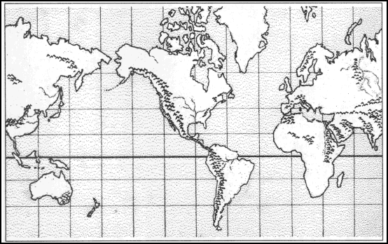
Figure 13-2. Mountain systems.
a. Major Systems. Major systems are listed in Table 13-2.
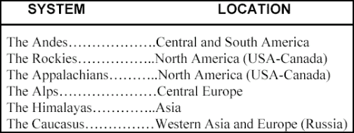
Table 13-2. Major systems.
b. Minor Systems. Some other systems are in Antarctica, Hawaii, Japan, New Zealand, and Oceania. Mountain systems are characterized by high, inaccessible peaks and steep slopes. Depending on the altitude, they may be snow covered. Prominent ridges and large valleys are also found. Navigating in this type of terrain is not difficult providing you make a careful examination of the map and the terrain.
c. Climate. Because of the elevations, it is always colder (3° to 5° per 300-meter gain in altitude) and wetter than you might expect. Wind speeds can increase the effects of the cold even more. Sudden severe storms and fog are encountered regularly. Below the tree line, vegetation is heavy because of the extra rainfall and the fact that the land is rarely cleared for farming.
d. Interpretation and Analysis. The heights of mountainous terrain permit excellent long-range observation. However, rapidly fluctuating weather with frequent periods of high winds, rain, snow, or fog may limit visibility. Also, the rugged nature of the terrain frequently produces significant dead space at mid-ranges.
(1) Reduced mobility, compartmented terrain, and the effects of rapidly changing weather increase the importance of air, ground, aerial photo, and map reconnaissance. Since mountain maps often use large contour intevals, microrelief interpretation and detailed terrain analysis require special emphasis.
(2) At first glance, some mountainous terrain may not appear to offer adequate cover and concealment; however, you can improve the situation. When moving, use rock outcroppings, boulders, and heavy vegetation for cover and concealment; use terrain features to mask maneuvers. Use harsh weather, which often obscures observation, to enhance concealment.
(3) Since there are only a few routing options, all-round security must be of primary concern. Natural obstacles are everywhere, and the enemy can easily construct more.
e. Navigation. Existing roads and trails offer the best routes for movement. Off-road movement may enhance security provided there is detailed reconnaissance, photo intelligence, or information from local inhabitants to ensure the route is negotiable. Again, the four steps and two techniques for navigation presented earlier remain valid in the mountains. Nevertheless, understanding the special conditions and the terrain will help you navigate. Other techniques that are sometimes helpful in mountains are:
(1) Aspect of Slope. To determine the aspect of slope, take a compass reading along an imaginary line that runs straight down the slope. It should cut through each of the contour lines at about a 90° angle. By checking the map and knowing the direction of slope where you are located, you will be able to keep track of your location, and it will help guide your cross-country movement even when visibility is poor.
(2) Use of an Altimeter. Employment of an altimeter with calibrations on the scale down to 10 or 20 meters is helpful to land navigators moving in areas where radical changes in elevation exist. An altimeter is a type of barometer that gauges air pressure, except it measures on an adjustable scale marked in feet or meters of elevation rather than in inches or centimeters of mercury. Careful use of the altimeter helps to pinpoint your position on a map through a unique type of resection. Instead of finding your position by using two different directional values, you use one directional value and one elevation value.
13-3. JUNGLE TERRAIN
These large geographic regions are found within the tropics near the equator (Central America, along the Amazon River, South-Eastern Asia and adjacent islands, and vast areas in the middle of Africa and India) (Figure 13-3). Jungles are characterized as rainy, humid areas with heavy layers of tangled, impenetrable vegetation. Jungles contain many species of wildlife (tigers, monkeys, parrots, snakes, alligators, and so forth). The jungle is also a paradise for insects, which are the worst enemy of the navigator because some insects carry diseases (malaria, yellow fever, cholera, and so forth). While navigating in these areas, very little terrain association can be accomplished because of the heavy foliage. Dead reckoning is one of the methods used in these areas. A lost navigator in the jungle can eventually find his way back to civilization by following any body of water with a downstream flow. However, not every civilization found is of a friendly nature.
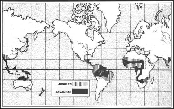
Figure 13-3. Jungles and savannas.
a. Operations. Operations in jungles tend to be isolated actions by small forces because of the difficulties encountered in moving and in maintaining contact between units. Divisions can move cross-country slowly; but, aggressive reconnaissance, meticulous intelligence collection, and detailed coordination are required to concentrate forces in this way. More commonly, large forces operate along roads or natural avenues of movement, as was the case in the mountains. Patrolling and other surveillance operations are especially important to ensure security of larger forces in the close terrain of jungles.
(1) Short fields of observation and fire, and thick vegetation make maintaining contact with the enemy difficult. The same factors reduce the effectiveness of indirect fire and make jungle combat primarily a fight between infantry forces. Support by air and mechanized forces can be decisive at times, but it will not always be available or effective.
(2) Jungles are characterized by high temperatures, heavy rains, high humidity, and an abundance of vegetation. The climate varies with location. Close to the equator, all seasons are nearly alike with heavy rains all year. Farther from the equator (India and Southeast Asia), there are distinct wet (monsoon) and dry seasons. Both zones have high temperatures (averaging 75 to 95+ degrees Fahrenheit), heavy rainfall (as much as 400+ inches annually, and high humidity (90 percent) all year.
(3) In temperate climates, it is the areas of vegetation that are most likely to be altered and incorrectly portrayed on a map. In jungle areas, the vegetation grows so rapidly that it is more likely to be cleared and make these areas be shown incorrectly.
b. Interpretation and Analysis. The jungle environment includes dense forests, grasslands, swamps, and cultivated areas. Forests are classified as primary and secondary based upon the terrain and vegetation. Primary forests include tropical rain forests and deciduous forests. Secondary forests are found at the edges of both rain forests and deciduous forests and in areas where jungles have been cleared and abandoned. These places are typically overgrown with weeds, grasses, thorns, ferns, canes, and shrubs. Movement is especially slow and difficult. The extremely thick vegetation reaches a height of 2 meters and severely limits observation to only a few meters.
(1) Tropical rain forests consist mostly of large trees whose branches spread and lock together to form canopies. These canopies, which can exist at two and three different levels, may form as low as 10 meters from the ground. They prevent direct sunlight from reaching the ground, causing a lack of undergrowth on the jungle floor. Extensive above-ground root systems and hanging vines are common and make vehicular travel difficult; foot movement is easier. Ground observation is limited to about 50 meters and air observation is nearly impossible.
(2) Deciduous forests are in semitropical zones that have both wet and dry seasons. In the wet season, trees are fully leaved; in the dry season, much of the folliage dies. Trees are usually less dense than in rain forests, which allows more sunlight to filter to the ground. This procedure produces thick undergrowth. During the wet season, air and ground observation is limited and movement is difficult. During the dry season, both improve.
(3) Swamps are common to all low, jungle areas where there is poor drainage. When navigating in a swampy area, a careful analysis of map and ground should be taken before any movement. The soldiers should travel in small numbers with only the equipment required for their mission, keeping in mind that they are going to be immersed in water part of the time. The usual technique used in swamp navigation is dead reckoning. There are two basic types of swamps—mangrove and palm. Mangrove swamps are found in coastal areas wherever tides influence water flow. Mangrove is a shrub-like tree that grows 1 to 5 meters high. These trees have a tangled root system, both above and below the waterline, which restricts movement either by foot or small boat. Observation on the ground and from the air is poor, but concealment is excellent.
(4) Grassy plains or savannas are generally located away from the equator but within the tropics. These vast land areas are characterized by flatlands with a different type of vegetation than jungles. They consist mainly of grasses (ranging from 1 to more than 12 feet in height), shrubs, and isolated trees. The most difficult areas to navigate are the ones surrounded by tall grass (elephant grass); however, vehicles can negotiate here better than in some areas. There are few or no natural features to navigate by, making dead reckoning or navigation by stars the only technique for movement (Figure 13-3). Depending on the height of the grass, ground observation may vary from poor to good. Concealment from air observation is poor for both soldiers and vehicles.
(5) Bamboo stands are common throughout the tropics. They should be bypassed whenever possible. They are formidable obstacles for vehicles, and soldier movement through them is slow, exhausting, and noisy.
(6) Cultivated areas exist in jungles also. They range from large, well-planned, well-managed farms and plantations to small tracts, cultivated by farmers. The three general types of cultivated areas are rice paddies, plantations, and small farms.
c. Navigation. Areas such as jungles are generally not accurately mapped because heavy vegetation makes aerial surveys difficult. The ability to observe terrain features, near or far, is extremely limited. The navigator must rely heavily upon his compass and the dead reckoning technique when moving in the jungle. Navigation is further complicated by the inability to make straight-line movements. Terrain analysis, constant use of the compass, and an accurate pace count are essential to navigation in this environment.
(1) Rates of movement and pace counts are particularly important to jungle navigators. The most common error is to overestimate the distance traveled. The distances below can be used as a rough guide for the maximum distances that might be traveled in various types of terrain during one hour in daylight.
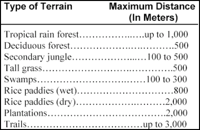
Table 13-3. Guide for maximum distance.
(2) Special navigation strategies that are helpful in jungles include:
(a) Personal pace table. You should either make a mental or written personal pace table that includes your average pace count per 100 meters for each of the types of terrain through which you are likely to navigate.
(b) Resection using indirect fire. Call for mortar or artillery fire (airbursts of white phosphorous or illumination) on two widely separated grids that are not on terrain features like the one you are occupying and are a safe distance from your estimated location. Directions to the airbursts sometimes must be determined by sound.
(c) Modified area/point navigation. Even when making primary use of the compass for dead reckoning, you are frequently able to area navigate to an expanded objective, which is easily identified by terrain association. Then, simply develop a short, point-navigation leg to your final destination.
13-4. ARCTIC TERRAIN
Arctic terrain includes those areas that experience extended periods of below freezing temperatures. In these areas, the ground is generally covered with ice or snow during the winter season. Although frozen ground and ice can improve trafficability, a deep accumulation of snow can reduce it. Vehicles and personnel require special equipment and care under these adverse conditions.
a. Operations. Both the terrain and the type and size of unit operations vary greatly in arctic areas. In open terrain, armored and mechanized forces will be effective although they will have to plan and train for the special conditions. In broken terrain, forests, and mountains, light forces will predominate as usual. However, foot movement can take up to five times as long as it might under warmer conditions.
b. Interpretation and Analysis. Both the terrain and cultural features you may confront in winter may vary to any extreme, as can the weather. The common factor is an extended period of below-freezing temperatures. The terrain may be plains, plateaus, hills, or mountains. The climate will be cold, but the weather will vary greatly from place to place. Most arctic terrain experiences snow, but some claim impressive accumulations each season, such as the lake-effected snow belts off Lake Ontario near Fort Drum, New York. Other areas have many cold days with sunshine and clear nights, and little snow accumulation.
(1) In areas with distinct local relief and scattered trees or forests, the absence of foliage makes movement by terrain association easier; observation and fields of fire are greatly enhanced except during snowstorms. But in relatively flat, open areas covered with snow (especially in bright sunlight), the resulting lack of contrast may interfere with your being able to read the land. With foliage gone, concealment (both from the ground and from the air) is greatly reduced. As in desert areas, you must make better use of the terrain to conceal your movements.
(2) Frozen streams and swamps may no longer be obstacles, and thus identification of avenues of approach may be difficult in winter. However, the concept as to what is key terrain is not likely to be affected.
c. Navigation. Special skills may be required in arctic terrain, such as the proper use of winter clothing, skis, and snowshoes; but this does not affect your navigation strategies. There are no special techniques for navigating in arctic terrain. Just be aware of the advantages and disadvantages that may present themselves and make the most of your opportunities while applying the four steps and two techniques for land navigation.
(1) Remember, the highest caliber of leadership is required to ensure that all necessary tasks are performed, that security is maintained, and that soldiers and their equipment are protected from the physical effects of very low temperatures. There is a great temptation to do less than a thorough job at whatever the task may be when you are very cold.
(2) Night navigation may be particularly enhanced when operating in arctic terrain. Moonlight and starlight on a clear night reflect off the snow, thus enabling you to employ daytime terrain association techniques with little difficulty. Even cloudy winter nights are often brighter than clear moonlit summer nights when the ground is dark and covered with foliage. Movements with complete light discipline (no black-out drives) can often be executed. On the other hand, areas with severe winter climates experience lengthy periods of darkness each day, which may be accompanied by driving snow and limited visibility.
13-5. URBAN AREAS
The world continues to become more urbanized each year; therefore, it is unlikely that all fighting will be done in rural settings. Major urban areas represent the power and wealth of a particular country in the form of industrial bases, transportation complexes, economic institutions, and political and cultural centers. Therefore, it may be necessary to secure and neutralize them. When navigating in urban places, it is man-made features, such as roads, railroads, bridges, and buildings that become important, while terrain and vegetation become less useful.
a. Interpretation and Analysis. Military operations on urbanized terrain require detailed planning that provides for decentralized execution. As a result of the rapid growth and changes occurring in many urban areas, the military topographic map is likely to be outdated. Supplemental use of commercially produced city maps may be helpful, or an up-to-date sketch can be made.
(1) Urbanized terrain normally offers many AAs for mounted maneuver well forward of and leading to urban centers. In the proximity of these built-up areas, however, such approach routes generally become choked by urban sprawl and perhaps by the nature of adjacent natural terrain. Dismounted forces then make the most of available cover by moving through buildings and underground systems, along edges of streets, and over rooftops. Urban areas tend to separate and isolate units, requiring the small-unit leader to take the initiative and demonstrate his skill in order to prevail.
(2) The urban condition of an area creates many obstacles, and the destruction of many buildings and bridges as combat power is applied during a battle further limits your freedom of movement. Cover and concealment are plentiful, but observation and fields of fire are greatly restricted.
b. Navigation. Navigation in urban areas can be confusing, but there are often many cues that will present themselves as you proceed. They include streets and street signs; building styles and sizes; the urban geography of industrial, warehousing, residential housing, and market districts; man-made transportation features other than streets and roads (rail and trolley lines); and the terrain features and hydrographic features located within the built-up area. Strategies for staying on the route in an urban area include:
(1) Process Route Descriptions. Write down or memorize the route through an urban area as a step-by-step process. For example, “Go three blocks north, turn left (west) on a wide divided boulevard until you go over a river bridge. Turn right (north) along the west bank of the river, and. . . “
(2) Conceptual Understandings of the Urban Area. While studying the map and operating in a built-up area, work hard to develop an understanding (mental map) of the entire area. This advantage will allow you to navigate over multiple routes to any location. It will also preclude your getting lost whenever you miss a turn or are forced off the planned route by obstacles or the tactical situation.
(3) Resection. Whenever you have a vantage point to two or more known features portrayed on the map, do not hesitate to use either estimated or plotted resection to pinpoint your position. These opportunities are often plentiful in an urban setting.
Land Navigation Training Software
- Chapter 1: TRAINING STRATEGY
- Chapter 2: MAPS
- Chapter 3: MARGINAL INFORMATION AND SYMBOLS
- Chapter 4: GRIDS
- Chapter 5: SCALE AND DISTANCE
- Chapter 6: DIRECTION
- Chapter 7: OVERLAYS
- Chapter 8: AERIAL PHOTOGRAPHS
- Chapter 9: NAVIGATION EQUIPMENT AND METHODS
- Chapter 10: ELEVATION AND RELIEF
- Chapter 11: TERRAIN ASSOCIATION
- Chapter 12: MOUNTED LAND NAVIGATION
- Chapter 13: NAVIGATION IN DIFFERENT TYPES OF TERRAIN
- Chapter 14: UNIT SUSTAINMENT
- Appendix A: FIELD SKETCHING
- Appendix B: MAP FOLDING TECHNIQUES
- Appendix C: UNITS OF MEASURE AND CONVERSION FACTORS
- Appendix D: JOINT OPERATIONS GRAPHICS
- Appendix E: EXPORTABLE TRAINING MATERIAL
- Appendix F: ORIENTEERING
- Appendix G: M2 COMPASS
- Appendix H: ADDITIONAL AIDS
- Appendix I: FOREIGN MAPS
- Appendix J: GLOBAL POSITIONING SYSTEM
- Appendix K: PRECISION LIGHTWEIGHT GLOBAL POSITIONING SYSTEM RECEIVER
- Map Reading and Land Navigation GLOSSARY
- Map Reading and Land Navigation REFERENCES