Chapter 12
MOUNTED LAND NAVIGATION
A vehicle commander should be able to navigate from one point on the ground to another with or without a compass. If separated from his unit and given an azimuth and distance from their position to his, he should be able to reach the unit and continue the mission. To move effectively while mounted, he must know the principles of mounted navigation.
12-1. PRINCIPLES
The principles of land navigation while mounted are basically the same as while dismounted. The major difference is the speed of travel. Walking between two points may take one hour, but riding the same distance may only take 15 minutes. To be effective at mounted land navigation, the travel speed must be considered.
12-2. NAVIGATOR’S DUTIES
The duties of a navigator are so important and exacting that he should not be given any other duties. The leader should never try to be the navigator, since his normal responsibilities are heavy, and one or the other job would suffer.
a. Assembling Equipment. The navigator must gather all the equipment that will help him perform his job (maps, pencils, and so forth). He must do this before the mission starts.
b. Servicing Equipment. It is the navigator’s duty to make sure that all the equipment he may use or require is working.
c. Recording Data for Precise Locations. During movement, the navigator must make sure that the correct direction and distance are recorded and followed. Grid coordinates of locations must be recorded and plotted.
d. Supplying Data to Subordinate Leaders. During movement, any change in direction or distance must be given to the subordinate leaders in sufficient time to allow them to react.
e. Maintaining Liaison with the Commander. The commander normally selects the route that he desires to use. The navigator is responsible for following that route; however, there may be times when the route must be changed during a tactical operation. For this reason, the navigator must maintain constant communication with the commander. The navigator must inform the commander when checkpoints are reached, when a change in direction of movement is required, and how much distance is traveled.
12-3. MOVEMENT
When preparing to move, the effects of terrain on navigating mounted vehicles must be determined. You will cover great distances very quickly, and you must develop the ability to estimate the distance you have traveled. Remember that 0.1 mile is roughly 160 meters, and 1 mile is about 1,600 meters or 1.6 kms. Having a mobility advantage helps while navigating. Mobility makes it much easier if you get disoriented to move to a point where you can reorient yourself.
NOTE:
a. Consider Vehicle Capabilities. When determining a route to be used when mounted, consider the capabilities of the vehicles to be used. Most military vehicles are limited in the degree of slope they can climb and the type of terrain they can negotiate. Swamps, thickly wooded areas, or deep streams may present no problems to dismounted soldiers, but the same terrain may completely stop mounted soldiers. The navigator must consider this when selecting a route.
(1) Most vehicles will knock down a tree. The bigger the vehicle, the bigger the tree it can knock down. Vehicles cannot knock down several trees at once. It is best to find paths between trees that are wide enough for your vehicle. Military vehicles are designed to climb 60 percent slopes on a dry, firm surface (Figure 12-1).
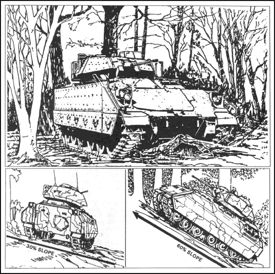
Figure 12-1. Tracked vehicle capabilities.
(2) You can easily determine approximate slope; just look at the route you have selected. If there is a contour line in any 100 meters of map distance on that route, it is a 10 percent slope. If there are two contour lines, it is 20 percent, and so forth. If there are four contour lines in any 100 meters, look for another route.
(3) Side slope is even more important than the slope you can climb. Normally, a 30 percent slope is the maximum in good weather. If you traverse a side slope, do it slowly and without turns. Rocks, stumps, or sharp turns can cause you to throw the downhill track under the vehicle, which would mean a big recovery task.
(4) For tactical reasons, you will often want to move in draws or valleys because they give you cover. However, side slopes force you to move slowly.
NOTE:
b. Know the Effects of Weather on Vehicle Movement. Weather can halt mounted movement. Snow and ice are obvious dangers, but more significant is the effect of rain and snow on soil load-bearing ability. Cross-country vehicles may be restricted to road movement in heavy rain. If it has rained recently, adjust your route to avoid flooded or muddy areas. A mired vehicle only hinders combat capability.
c. Prepare Before Movement. Locate the start point and finish point on the map. Determine the map’s grid azimuth from start point to finish point and convert it to a magnetic azimuth. Determine the distance between the start point and finish point or any intermediate points on the map and make a thorough map reconnaissance of that area.
12-4. TERRAIN ASSOCIATION NAVIGATION
This is currently the most widely used method of navigation. The navigator plans his route so that he moves from terrain feature to terrain feature. An automobile driver in a city uses this technique as he moves along a street or series of streets, guiding on intersections or features such as stores and parks. Like the driver, the navigator selects routes or streets between key points or intersections. These routes must be capable of sustaining the travel of the vehicle or vehicles, should be relatively direct, and should be easy to follow. In a typical move, the navigator determines his location, determines the location of his objective, notes the position of both on his map, and then selects a route between the two. After examining the terrain, he adjusts the route by the following actions:
a. Consider Tactical Aspects. Avoid skylining, select key terrain for overwatch positions, and select concealed routes.
b. Consider Ease of Movement. Use the easiest possible route and bypass difficult terrain. Remember that a difficult route is harder to follow, is noisier, causes more wear and tear (and possible recovery problems), and takes more time. Tactical surprise is achieved by doing the unexpected. Try to select an axis or corridor instead of a specific route. Make sure you have enough maneuver room for the vehicles (Figure 12-2).
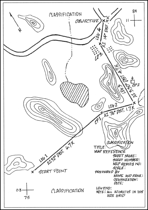
Figure 12-2. Primary route.
c. Use Terrain Features as Checkpoints. These checkpoints must be easily recognizable in the light and weather conditions and at the speed at which you will move. You should be able to find a terrain feature from your location that can be recognized from almost anywhere and used as a guide. An example is checkpoint 2, the church, and checkpoint 3, the orchard, in Figure 12-2.
(1) The best checkpoints are linear features that cross your route. Use streams, rivers, hard-top roads, ridges, valleys, and railroads.
(2) The next best checkpoints are elevation changes, such as hills, depressions, spurs, and draws. Look for two contour lines of change. You will not be able to spot less than two lines of change while mounted.
(3) In wooded terrain, try to locate checkpoints at no more than 1,000-meter intervals. In open terrain, you may go to about 5,000 meters.
d. Follow Terrain Features. Movement and navigation along a valley floor or near (not necessarily on) the crest of a ridgeline is easiest.
e. Determine Directions. Break the route down into smaller segments and determine the rough directions that will be followed. You do not need to use the compass; just use the main points of direction (north, northeast, east, and so forth). Before moving, note the location of the sun and locate north. Locate changes of direction, if any, at the checkpoints picked.
f. Determine Distance. Get the total distance to be traveled and the approximate distance between checkpoints. Plan to use the vehicle odometer to keep track of distance traveled. Use the pace-count method and keep a record of the distance traveled. When using a pace count, convert from map distance to ground distance by adding the conversion factors of 20 percent for cross-country movement.
g. Make Notes. Mental notes are usually adequate. Try to imagine what the route is like and remember it.
h. Plan to Avoid Errors. Restudy the route selected. Try to determine where errors are most apt to occur and how to avoid any trouble.
i. Use a Logbook. When the routes have been selected and the navigator has divided the distance to be traveled into legs, prepare a logbook. The logbook is an informal record of the distance and azimuth of each leg, with notes to aid the navigator in following the correct route. The notes list easily identifiable terrain features at or near the point where the direction of movement changes (Figure 12-3).
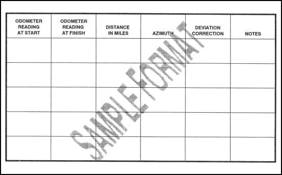
Figure 12-3. Sample of a logbook format.
12-5. DEAD RECKONING NAVIGATION
Dead reckoning is moving a set distance along a set line. Generally, it involves moving so many meters along a set line, usually an azimuth in degrees. There is no accurate method of determining a direction in a moving vehicle. A magnetic vehicle-heading reference unit may be available in a few years; for now, use a compass.
a. With Steering Marks. This procedure is the same for vehicle travel as on foot.
(1) The navigator dismounts from the vehicle and moves away from the vehicle (at least 18 meters).
(2) He sets the azimuth on the compass and picks a steering mark (rock, tree, hilltop) in the direction on that azimuth (Figure 12-4).
(3) He remounts and has the driver identify the steering mark and proceeds to it in as straight a line as possible.
(4) On arrival at the steering mark or on any changes in direction, he repeats the first three steps above for the next leg of travel.
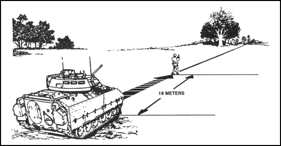
Figure 12-4. Determining an azimuth, dismounted.
b. Without Steering Marks. This procedure is used only on flat, featureless terrain.
(1) The navigator dismounts from the vehicle, which is oriented in the direction of travel, and moves at least 18 meters to the front of the vehicle.
(2) He faces the vehicle and reads the azimuth to the vehicle. By adding or subtracting 180º, he determines the forward azimuth (direction of travel).
(3) On order from the navigator, the driver drives on a straight line to the navigator.
(4) The navigator remounts the vehicle, holds the compass as it will be held while the vehicle is moving, and reads the azimuth in the direction of travel.
(5) The compass will swing off the azimuth determined and pick up a constant deviation. For instance, say the azimuth was 75º while you were away from the vehicle. When you remounted and your driver drove straight forward, your compass showed 67º. You have a deviation of -8º. All you need to do is maintain that 67º compass heading to travel on a 75º magnetic heading.
(6) At night, the same technique can be used. From the map, determine the azimuth you are to travel. Convert the grid azimuth to a magnetic azimuth. Line the vehicle up on that azimuth, then move well in front of it. Be sure it is aligned correctly. Then mount, have the driver move slowly forward, and note the deviation. If the vehicle has a turret, the above procedure works unless you traverse the turret; this changes the deviation.
(7) The distance factor in dead reckoning is easy. Just determine the map distance to travel and add 20 percent to convert to ground distance. Use your vehicle odometer to be sure you travel the proper distance.
12-6. STABILIZED TURRET ALIGNMENT NAVIGATION
Another method, if you have a vehicle with a stabilized turret, is to align the turret on the azimuth you wish to travel, then switch the turret stabilization system on. The gun tube remains pointed at your destination no matter which way you turn the vehicle. This technique has been proven; it works. It is not harmful to the stabilization system. It is subject to stabilization drift, so use it for no more than 5,000 meters before resetting.
NOTE:
12-7. COMBINATION NAVIGATION
Some mounted situations may call for you to combine and use both methods. Just remember the characteristics of each.
a. Terrain association is fast, is error-tolerant, and is best under most circumstances. It can be used day or night if you are proficient in it.
b. Dead reckoning is very accurate if you do everything correctly. You must be very precise. It is also slow, but it works on very flat terrain.
c. You frequently will combine both. You may use dead reckoning to travel across a large, flat area to a ridge, then use terrain association for the rest of the move.
d. You must be able to use both methods. You should remember that your probable errors, in order of frequency, will be—
-
Failure to determine distance(s) to be traveled.
-
Failure to travel the proper distance.
-
Failure to properly plot or locate the objective.
-
Failure to select easily recognized checkpoints or landmarks.
-
Failure to consider the ease of movement factor.
Land Navigation Training Software
- Chapter 1: TRAINING STRATEGY
- Chapter 2: MAPS
- Chapter 3: MARGINAL INFORMATION AND SYMBOLS
- Chapter 4: GRIDS
- Chapter 5: SCALE AND DISTANCE
- Chapter 6: DIRECTION
- Chapter 7: OVERLAYS
- Chapter 8: AERIAL PHOTOGRAPHS
- Chapter 9: NAVIGATION EQUIPMENT AND METHODS
- Chapter 10: ELEVATION AND RELIEF
- Chapter 11: TERRAIN ASSOCIATION
- Chapter 12: MOUNTED LAND NAVIGATION
- Chapter 13: NAVIGATION IN DIFFERENT TYPES OF TERRAIN
- Chapter 14: UNIT SUSTAINMENT
- Appendix A: FIELD SKETCHING
- Appendix B: MAP FOLDING TECHNIQUES
- Appendix C: UNITS OF MEASURE AND CONVERSION FACTORS
- Appendix D: JOINT OPERATIONS GRAPHICS
- Appendix E: EXPORTABLE TRAINING MATERIAL
- Appendix F: ORIENTEERING
- Appendix G: M2 COMPASS
- Appendix H: ADDITIONAL AIDS
- Appendix I: FOREIGN MAPS
- Appendix J: GLOBAL POSITIONING SYSTEM
- Appendix K: PRECISION LIGHTWEIGHT GLOBAL POSITIONING SYSTEM RECEIVER
- Map Reading and Land Navigation GLOSSARY
- Map Reading and Land Navigation REFERENCES