APPENDIX G
M2 COMPASS
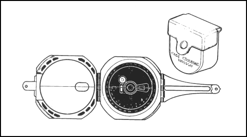
The M2 compass (Figure G-1) is a rustproof and dustproof magnetic instrument that provides slope, angle of site, and azimuth readings. One of the most important features of the M2 compass is that it is graduated in mils and does not require a conversion from degrees to mils as does the M1 compass. It can be calibrated to provide a grid azimuth or it can be used uncalibrated to determine a magnetic azimuth.

Figure G-1. M2 compass.
G-1. MAGNETIC NEEDLE
Except for the magnetic needle and its pivot, the compass is made of nonmagnetic materials. When the cover is closed, the magnetic needle is automatically lifted from its pivot and held firmly against the glass window. When the compass is open and leveled, the needle floats freely upon its pivot and points to magnetic north. Note that both ends of the needle are shaped like an arrow, and that one arrow is painted white and the other is black. It is the white end of the needle that points to magnetic north. Because the needle is magnetic, it will also be attracted to large iron or steel objects in the near vicinity, to electrical power lines, and to operating generators (see paragraph 9-3b). Magnetic compass readings measured near such objects are apt to be in error due to the magnetic attraction of these objects.
G-2. CIRCULAR LEVEL
The M2 compass has a circular level that is used to level the instrument when measuring azimuths. The circular level bubble must be centered before reading the azimuth. The compass is equipped with front and rear sights for aligning on the object to which the azimuth is desired.
G-3. COMPASS AZIMUTH SCALE
The compass azimuth scale is a circle divided into 6400 mils. Beginning with zero, the graduations are numbered every 200 mils. The long, unnumbered graduations appearing halfway between the numbered graduations are the odd-numbered hundreds (100, 300, 500, and so forth). Short graduation marks divide each 100-mil segment into equal portions of 20 mils.
a. Reading the Azimuth Scale. Azimuths are read from the azimuth scale from the black end of the compass needle.
b. Setting Up the Compass. To set up the M2 compass, open the cover and fold the rear sight holder out parallel with the face of the compass. Fold the rear sight up, perpendicular with its holder. Fold the front sight up, parallel with the mirror. Then fold the cover (mirror) toward the compass until it is at an angle of approximately 45 degrees to the face of the compass so that, with your eye behind the rear sight, the black end of the compass needle can be readily viewed in the mirror. The compass is now set up for measuring an azimuth.
c. Measuring an Azimuth. Once the compass is set up and all steel objects are at least 18 meters away from your position, you are ready to measure an azimuth. Hold the compass in both hands at eye level with your arms braced against your body and with the rear sight nearest your eyes. Sight through the rear sight and the window in the mirror and align the hairline at the reflection of the face of the compass. Center the circular level bubble. With the bubble centered and the hairline aligned on the object, look at the mirror reflection of the compass scale and read the azimuth to which the black end of the needle is pointing. Remember, magnetic attractions or movement by you may cause errors in your readings.
Land Navigation Training Software
- Chapter 1: TRAINING STRATEGY
- Chapter 2: MAPS
- Chapter 3: MARGINAL INFORMATION AND SYMBOLS
- Chapter 4: GRIDS
- Chapter 5: SCALE AND DISTANCE
- Chapter 6: DIRECTION
- Chapter 7: OVERLAYS
- Chapter 8: AERIAL PHOTOGRAPHS
- Chapter 9: NAVIGATION EQUIPMENT AND METHODS
- Chapter 10: ELEVATION AND RELIEF
- Chapter 11: TERRAIN ASSOCIATION
- Chapter 12: MOUNTED LAND NAVIGATION
- Chapter 13: NAVIGATION IN DIFFERENT TYPES OF TERRAIN
- Chapter 14: UNIT SUSTAINMENT
- Appendix A: FIELD SKETCHING
- Appendix B: MAP FOLDING TECHNIQUES
- Appendix C: UNITS OF MEASURE AND CONVERSION FACTORS
- Appendix D: JOINT OPERATIONS GRAPHICS
- Appendix E: EXPORTABLE TRAINING MATERIAL
- Appendix F: ORIENTEERING
- Appendix G: M2 COMPASS
- Appendix H: ADDITIONAL AIDS
- Appendix I: FOREIGN MAPS
- Appendix J: GLOBAL POSITIONING SYSTEM
- Appendix K: PRECISION LIGHTWEIGHT GLOBAL POSITIONING SYSTEM RECEIVER
- Map Reading and Land Navigation GLOSSARY
- Map Reading and Land Navigation REFERENCES